Essential Lens: Analyzing Photographs Across the Curriculum
Processes of Science: Mars, a Case Study
Introduction
This collection is unique in that it focuses on the eight practices of science and engineering from the NGSS standards. Photographs and the data they provide are important tools for scientists.
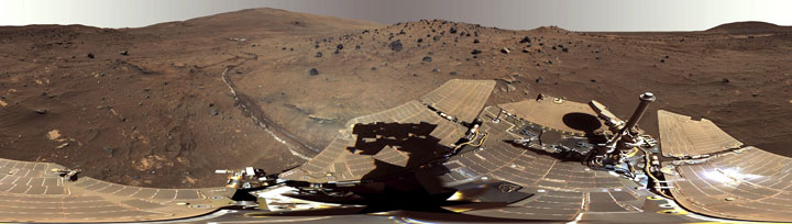
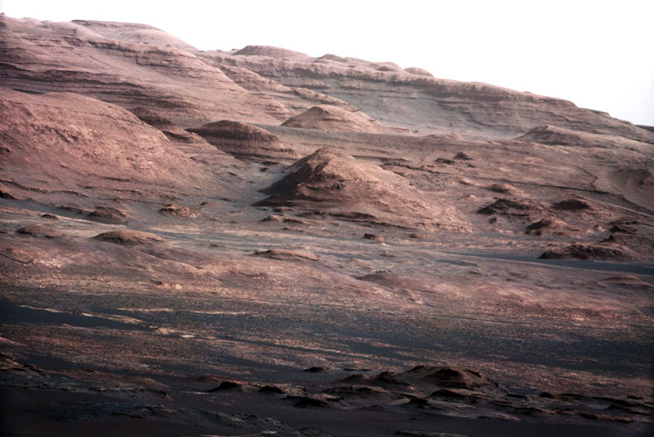
#6016 Spirit Mars Rover in McMurdo Panorama
This 360-degree view, called the “McMurdo” panorama, comes from the Panoramic Camera (Pancam) on NASA’s Mars Exploration Rover Spirit. From April through October 2006, Spirit stayed on a small hill known as “Low Ridge.”
Understanding the nature and practice of science is important for the critical thinking skills required in the 21st century. This understanding is a key part of the Framework for K-12 Education in Science, is considered essential for learning science, and is one of the strands woven into all of the NGSS performance expectations.
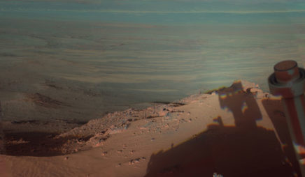
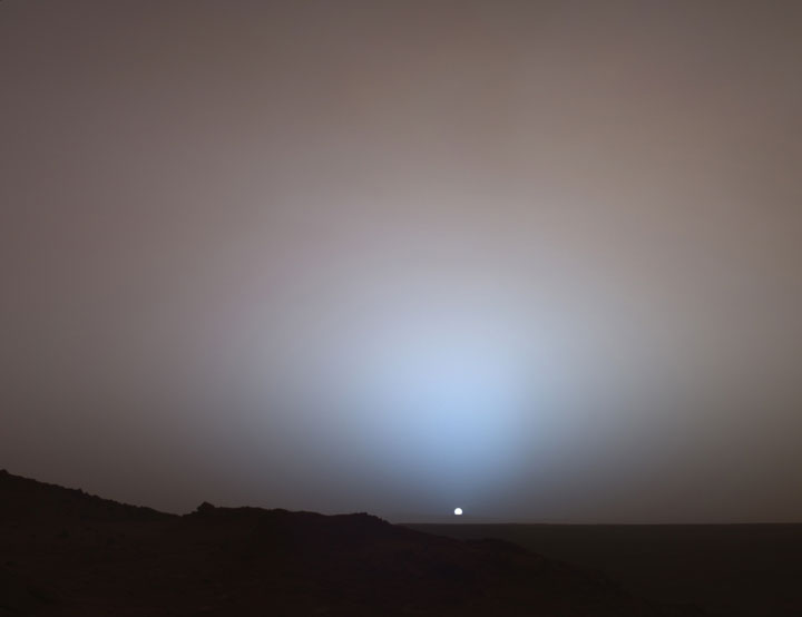
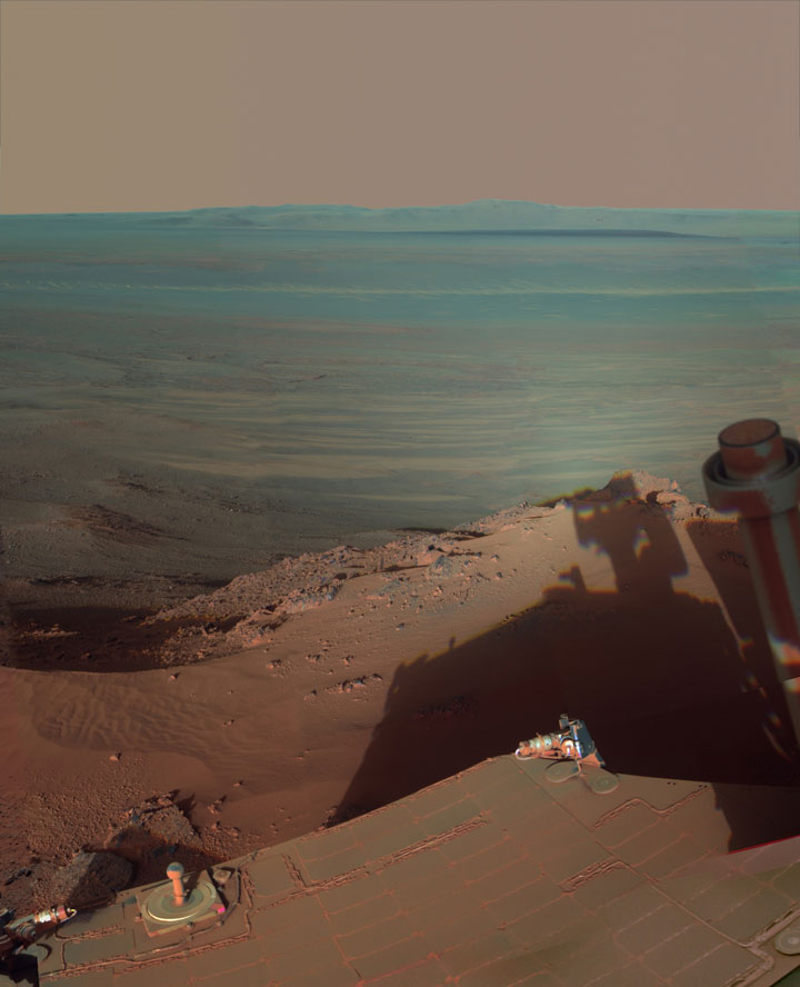
#6022 Late Afternoon Shadows at Endeavour Crater on Mars
NASA’s Mars Rover Opportunity catches its own late-afternoon shadow in this dramatically lit view eastward across Endeavour Crater on Mars.
In this collection, the investigation of water on Mars illustrates selected parts of the NGSS goals for understanding the nature of science and the processes of science and engineering. The collection illustrates how photographs are an essential data source for scientific investigation of remote and inaccessible locations, such as other planets.
Of the eight practices of science and engineering in the NGSS, students will model the following in the activities for this collection:
- Asking questions (for science) and defining problems (for engineering)
- Analyzing and interpreting data
- Constructing explanations (for science) and designing solutions (for engineering)
- Engaging in argument from evidence
- Obtaining, evaluating, and communicating information
The specific NGSS goals about the nature of science that are illustrated by this collection are:
- Scientific investigations use a variety of methods.
- Scientific knowledge is based on empirical evidence.
- Scientific knowledge is open to revision in light of new evidence.
- Science models, laws, mechanisms, and theories explain natural phenomena.
Students will use photos from the National Aeronautics and Space Administration (NASA) Mars Exploration Rover mission as a source of data, engaging in some of the practices of science while learning more about the Mars Rover mission, including the search for evidence of water
Key Learning Targets
Students will:
- Learn that photographs can be a data source for scientific investigation and evaluation.
- Have the opportunity to critically evaluate information from photographs, similar to the way they evaluate observations and measurements obtained through other methods.
- Understand the nature of science.
- Develop skills related to the practices of science and engineering in the context of the NASA Mars Rover mission.
Essential Questions
These big ideas or essential questions organize the content and topics of this collection of photographs. Students will consider the following questions:
- What are some methods that scientists use to study inaccessible places, such as other planets?
- What part do photographs play in observing and learning about Mars?
- What challenges do scientists have to overcome to study remote locations?
- What are some general practices that scientists use no matter what topic they are studying?
Prerequisite Knowledge
This photo collection and its activities require only general knowledge about the effects of water on Earth’s features. The activities in this collection might be appropriate for the beginning of the school year. The activities and questions will give students a background in the nature of science, as well as skills in the practice of science that they can use for more specific science content later in the year.
Activating Students’ Prior Knowledge
Middle & High School
Earth and Space Science, Engineering

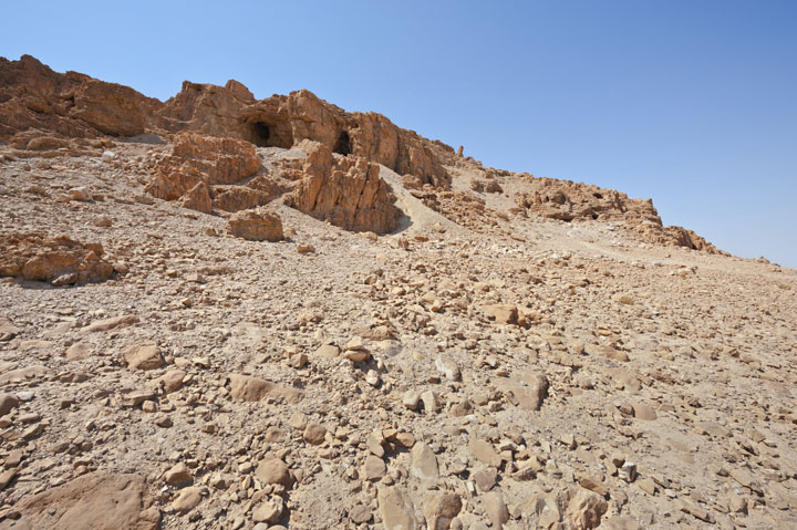
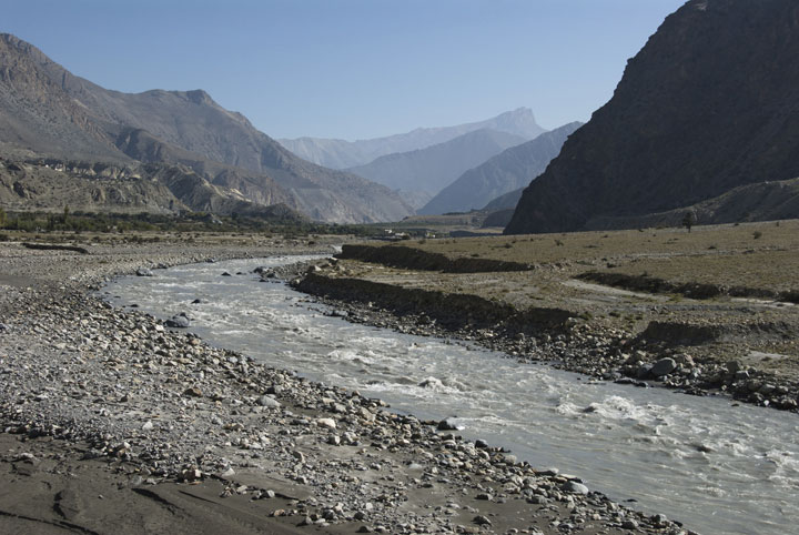
#6035 Desert Canyon
The Perazim canyon. Judean Desert nature reserve, Israel.
In pairs or small groups, have students look at photos of locations on Earth that show the effects of seasonal water: dry river beds, lake beds, and canyons. To apply the NGSS science and engineering practice of analyzing and interpreting data— specifically data from photos — students will observe, discuss, and list the evidence in the photos that indicates that water was once present. Have students review the photographic evidence of the impact of water and make a chart of the similarities and differences in the photos. (For example, students might notice patterns or placements of rocks that suggest they were moved by water. They might observe soil or rock erosion that suggests a current.)
Water on Mars: A Case Study
Middle & High School
Earth and Space Science, Engineering
Background
This information is not for classroom content, but to prepare teachers for the photographs, activities, and potential questions from students.
The Mars Exploration Rover Mission is part of a larger NASA Mars Exploration program. The two NASA Mars rovers, named Spirit and Opportunity, are solar-powered, six-wheeled robots that are 1.5 meters (4.9 feet) tall and 1.6 meters (5.2 feet) long. They weigh 174 kilograms (384 pounds). They have special suspension for driving over rough terrain, airbags for cushioning their landing, and a lot of equipment for taking images and sending them back to Earth.
LEARNING TARGETS
- I can ask testable scientific questions based on observations.
- I can make observations, gather evidence, provide explanations and alternative explanations, and formulate hypotheses to explain natural phenomena.
- I can engage in arguments based on evidence and provide appropriate evidence, including photographic evidence, to support claims.
- I can communicate science and engineering information.
#6013 Short, Fast Run
Around 200 kilometers long, Ravi Vallis was born in a flood of water from Aromatum Chaos (left).
Date: unknown
Location: unknown
Photographer: unknown
Source: NASA/JPL/Arizona State University, R. Luk
In 2000, NASA decided to send two rovers to Mars in summer 2003, when the orbits of Earth and Mars would bring the planets exceptionally close together. The initial cost to build, launch, and land the rovers was $280 million. Four extensions of the exploration since the initial phase have cost $104 million.The rovers collect data on the current and past conditions of Mars to see if the planet could have supported life as we know it on Earth. The rovers carry equipment to take samples and test their chemical compositions. They also carry cameras as an additional method for gathering scientific data. One question the mission wanted to answer by taking photographs of the terrain and other features of Mars was if the planet once had water on its surface.
Scientists are examining the evidence the rovers have found so far, including photographs of landscapes that look like former riverbeds or lake basins, and images that resemble the formation, weathering, and erosion of rocks by water. The rovers sent test results that suggest the presence of chemicals and minerals that, on Earth, form in the presence of liquid water. NASA lost contact with Spirit in 2010. As of 2014, Opportunity was still active.
Part 1
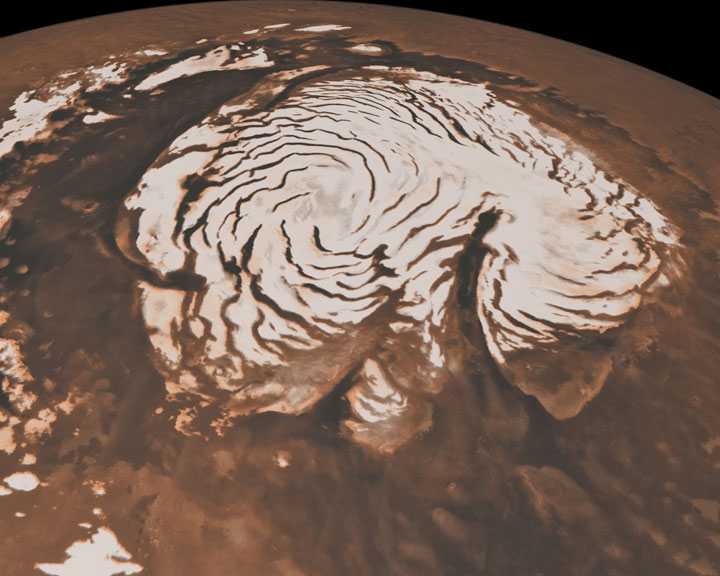
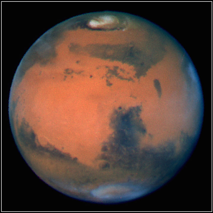
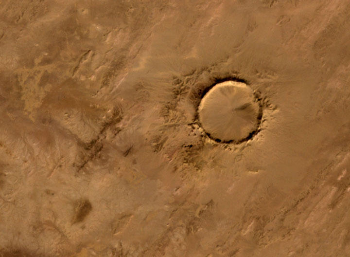
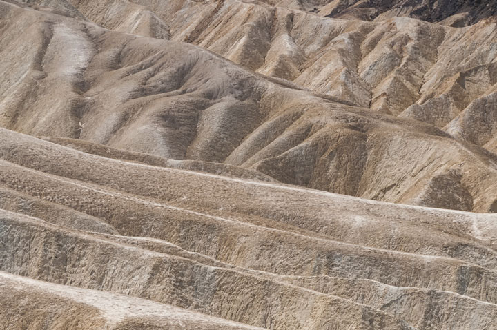
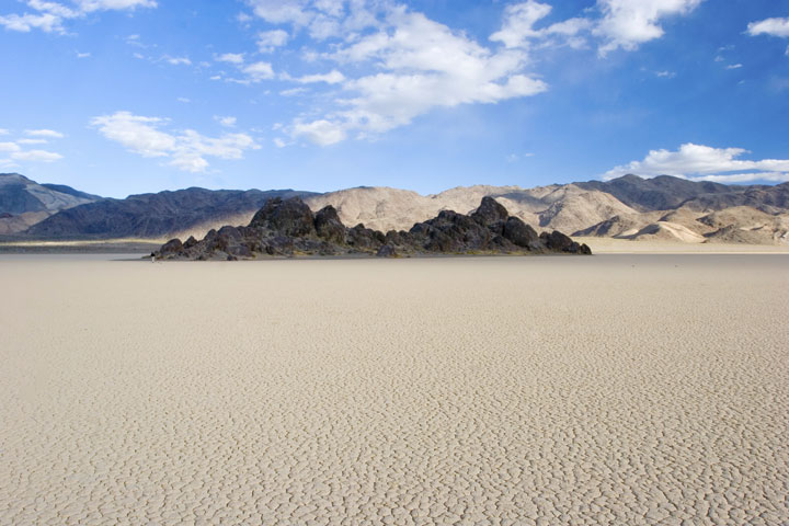
Give students, working in pairs or small groups, a sample of photos of Earth and Mars. Tell the students which photos show Earth and which show Mars, and ask them to group photos that show similar features on the two planets. Have the student teams study the photos carefully to identify similarities and differences of the features. Examples of photos they might match are 6037 and 6026 (Earth riverbeds) with 6012, 6017, 6018, or 6021 (Mars); craters in 6031 (Earth) with 6023 (Mars); rocky hills and ridges in 6032 and 6034 (Earth) with 6011, 6012, or 6019 (Mars); and whole planets in 6030 (Earth) and 6029 (Mars). As in the warm-up activity, students might notice features such as rock movement, or rock and soil erosion.

#6026 Riverbed
Desert on the West Bank of the Jordan River.
Date: 2013
Location: unknown
Photographer: unknown
Source: iStock
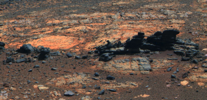
#6017 Link to a Watery Past
In this image from NASA’s Curiosity rover, a rock outcrop, called “Link,” pops out from a Martian surface that is elsewhere blanketed by reddish-brown dust. The fractured Link outcrop has blocks of exposed, clean surfaces.
Part 2
Have the students create a list of questions prompted by looking at the photos and comparing features of Earth and Mars. Because Mars is less familiar, ask the students what additional questions come to mind when they study the Mars photos. (Optional: Students can view images of Mars on the NASA website, a link is provided in References and Further Reading, and choose other photos to study.) For example, students might think of engineering problems that have to be overcome to explore Mars. Encourage students to ask each other questions about what they saw in the photos that led to each question.
#6005 Dry Ice Gone Wild
Note for teachers: Emphasize that at this point, no questions are considered right or wrong. This exercise is to experience the science and engineering practice of asking questions.
As a class, have groups share what they saw when they compared in their Earth and Mars photos and what questions the photos generated. (Teachers can choose whether the questions should be somewhat realistic, or if students should share any ideas they had—no matter how fanciful.) As a class, make a list of science questions and engineering problems from the small groups. Ask students if they have possible explanations for any of the questions or solutions to the problems (either their own ideas or ideas they have heard from other sources).
Optional: Have students choose a question and research it outside of class time to find out if scientists are studying the question.
Part 3
From the list of questions from the class list generated in Part 2, ask students to point out which questions are testable, meaning they could be answered if the appropriate data were available. Mark the testable questions (for example, with a star).
Optional: Ask students to list the problems engineers had to overcome to create the rovers and get the photos and other evidence. Have students discuss possible ways to overcome the problems.
Note for teachers: This exercise aligns with NGSS practices of science and engineering: asking questions (for science) and defining problems (for engineering). It reinforces the NGSS goal about understanding the nature of science by illustrating that science uses a variety of methods, and that scientific knowledge is based on empirical evidence.
Part 4
From the questions that the students labeled as testable, mark the questions that are related to finding out if Mars ever had water. (See Extensions for activities using the other questions.) If necessary, reframe the questions as a single, testable, scientific question about water on Mars, such as “Is there evidence that Mars ever had water? If so, what is it?”

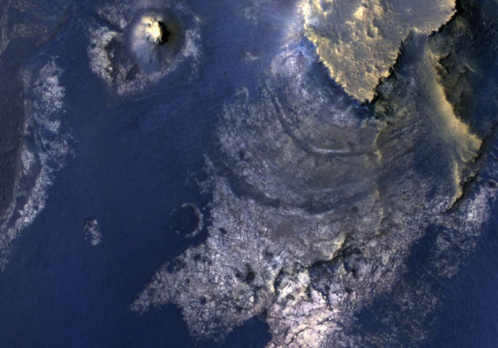
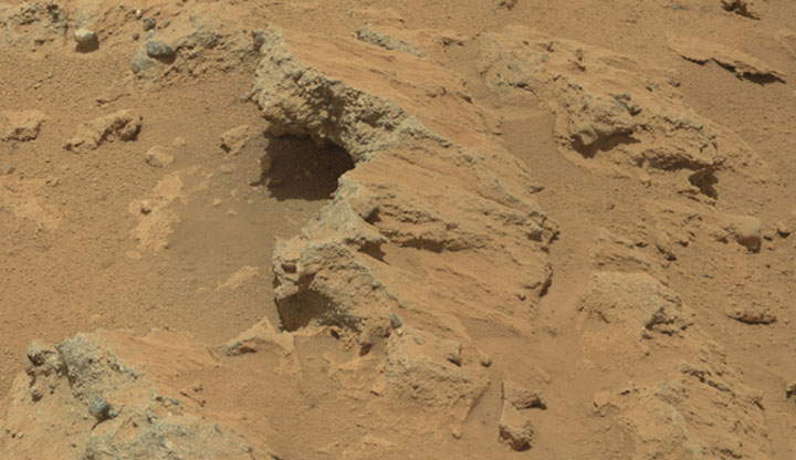
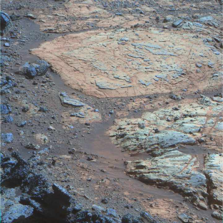
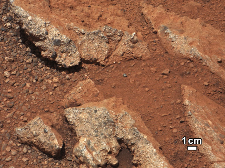
#6018 Remnants of Ancient Streambed on Mars
Source: NASA/JPL-Caltech/MSSS
In pairs or small groups, have students study the photos of Mars and look for evidence that does or does not support the hypothesis that water activity on Mars in the past shaped the current features of the planet. Ask the students to write an explanation based on the evidence they see. Their explanation should include alternate explanations for the evidence. (Having students use a “claim, evidence, reasoning” framework helps them structure their explanation.)
Optional: Have groups of students create a poster instead of writing their explanation. On copies of pictures, students could draw arrows and specifically label the evidence they see and provide a few brief sentences that describe the evidence.
Tell students that some scientists think that the available evidence about Mars so far supports previous life, while others think it does not. Ask students to choose one side or the other based on the evidence from the photographs they saw. Encourage students to think about the needs and characteristics of living things (with a mini-lecture on these points if students have not learned these concepts yet). Give students the opportunity to work with a partner who represents the opposing side. Students will develop a strategy to construct and present arguments based on empirical evidence and scientific reasoning, share their ideas, compare and respectfully critique arguments, get advice from their partner, and revise their own work.
Finally, have students communicate their combined information in a slideshow presentation, or write a paper, that shares the photos they used as evidence. The presentation should explain how the photos support or do not support the hypothesis of past life on Mars. Students should include ideas they revised as a result of working with their partner and should be prepared to answer questions from the teacher or classmates.
Note for teachers: This exercise aligns with NGSS practices of science and engineering, specifically engaging in argument from evidence; analyzing and interpreting data; developing models; and obtaining, evaluating, and communicating information. It models how scientists present information at conferences. It reinforces the NGSS concepts about understanding the nature of science that state that scientific knowledge is based on empirical evidence and is open to revision in light of new evidence, and that science models, laws, mechanisms, and theories explain natural phenomena.
Extension Activities
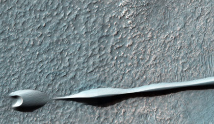
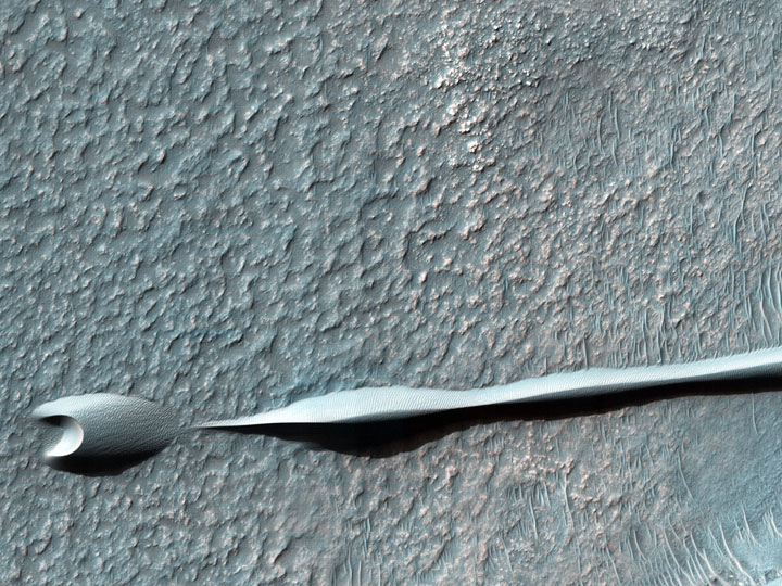
#6008 Barchan Dunes on the Move
Sand dunes such as those seen in this image have been observed to creep slowly across the surface of Mars through the action of the wind. These are a particular type of dune called a “barchan,” which forms when the wind blows in one direction (here, east to west) for long periods. Barchan dunes are common on Mars and in the desert regions of the Earth.
- The class generated a list of testable questions and problems from looking at the Mars photos. Choose one of the questions or problems that was not about water on Mars, and then write a paper or prepare a presentation with photographs about it. Some questions to answer might be:
- Are scientists and engineers investigating this question or problem? If so, what are they finding?
- How are photographs providing data to answer the question or solve the problem? (Or how might they provide data to answer the question?)
- What challenges to answering the question or solving the problem remain, and what are some potential solutions? How could photography help?
- Think of another scientific topic that is difficult to study without photographs (for example, a location is difficult to access). List some testable questions about the topic that might be answered with photographs. Write a paper or prepare a presentation (possibly using photographs), describing how photography allows us to study the topic and how photographs could allow us to study testable questions on the topic. Potential areas are microbiology, the study of remote areas (such as the Earth’s poles and oceans), the study of other features of space, and observing and comparing events over time, such as changes in polar ice caps.
Optional issues to explore are other ways to gather data and engineering solutions for photographing inaccessible locations. - Look at one of the Mars photographs that has been enhanced (such as 6002, 6012, or 6022). As a class or in small groups, discuss whether altering the color, contrast, or other features of a photograph changes its use as a scientific data source. How does editing change (1) the usefulness of the photograph, (2) the objectivity with which a scientist might analyze and interpret the information in the photograph, (3) whether the photograph can be used as evidence, and (4) how the photograph might be used to communicate scientific information?
Standards
The content is in accordance with the Next Generation Science Standards (NGSS), Appendices F and H, on the nature and practices of science; and Disciplinary Core Ideas: Earth and Space Sciences ESS3, Earth and Human Activity from the 2012 Framework for K-12 Science Education from the National Research Council of the National Academy of Science. (See references in. this unit.)
References and Further Readings
Next Generation Science Standards, Appendices F (Science and Engineering Practices) and H (Nature of Science)
http://www.nextgenscience.org/next-generation-science-standards
Framework for Science Education
A Framework for K–12 Science Education. Practices, Crosscutting Concepts, and Core Ideas
http://www.nap.edu/catalog.php?record_id=13165
Mars Exploration Program, National Aeronautics and Space Administration
http://mars.jpl.nasa.gov
Additional Images of Mars
http://mars.jpl.nasa.gov/multimedia/images