

Essential Lens: Analyzing Photographs Across the Curriculum
Focus in on This Photo: Drew Point, Alaska

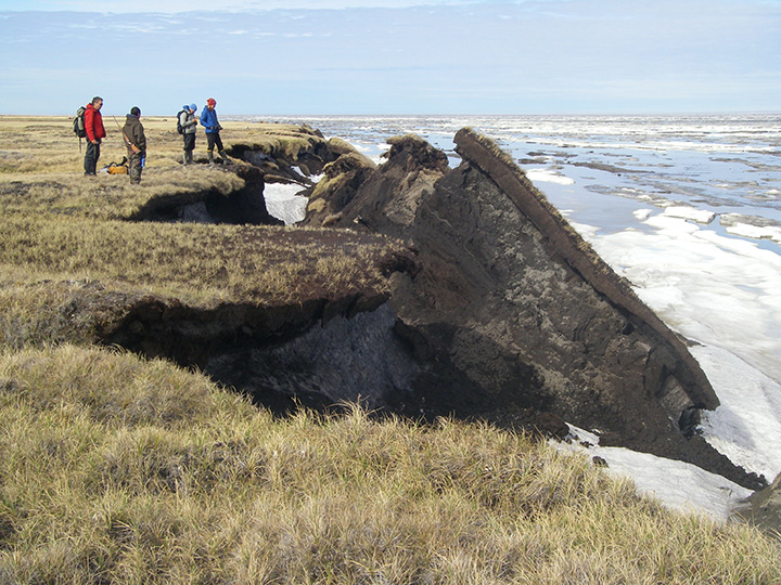
#3520 The color photograph depicts four people standing at the edge of a grassy cliff. Large pieces of earth have broken off into the icy water below.
Metadata
Date: June 20, 2008
Location: Alaska
Photographer: unknown
Source: Stratus Consulting/University of Colorado
Caption
Near Drew Point, Alaska, along the northern coast. The photo shows what often follows such undercutting: chunks of coastline tumbling into the sea. Ocean waves slowly eat away coastal cliffs the world over, but in parts of Alaska, these processes have accelerated due to changing climate. There, coastal erosion owes its accelerated pace to two climate-driven phenomena: declining sea ice and thawing permafrost.
Permafrost is defined as ground (soil or rock and included ice or organic material) that remains at or below 0°C for at least two consecutive years.
Observe

 There is land in the foreground, water to the right, the sky above, and four people standing in the background.

 On the left side of the photograph, the coastline is grassy and jagged, and pieces of it have broken off and fallen into the icy ocean, which is covered with ice.

 More broken pieces of land are visible in the background.

 In the center of the photograph is a large chunk of land that has broken off and collapsed into the ocean. The group of people standing on the left appears to be studying it.
Build on Your Observations

 The focal point of the composition is the large chunk of land that has broken off. The photographer has cut off the view on the right side, but there is still enough for the viewer to see the ocean on the right side. The caption describes declining sea ice, and the broken-up ice in the water illustrates this.

 The vantage point allows the viewer to see that the piece that has broken off is layered: different textures distinguish that the grassy portion is distinct from the more granular looking lower layer.

 The inclusion of the people in the photograph provides an indication of the scale of the landscape. The viewer understands these are massive pieces of land, and the viewer also gains a sense of how deep the permafrost layer extends—a depth that is deeper than the height of the humans standing on the ledge.
Make Inferences

 The chunk of earth in the center of the image becomes more significant when viewed with information from the caption, which mentions thawing permafrost.

 The photographer is illustrating a relationship between higher sea level and thawing permafrost, which destabilizes the soil and rock: as a result, the land erodes and drops off into the ocean. The caption tells us this is occurring at an accelerated pace, and the inclusion of the people in the image add a sense of urgency to the image.

 The particular geology of Drew Point makes this area particularly susceptible to erosion. The view of the land and ocean beyond the group of people illustrates this by showing this phenomenon is occurring further down the coastline and beyond the immediate space of the image.
Formulate Further Questions
In what regions is permafrost found? Where is the oldest permafrost?
What impact does the thawing permafrost have on the human, habitats, and cultural traditions of these regions?