The Habitable Planet: A Systems Approach to Environmental Science
Atmosphere Interview with Kerry Emanuel
Interviewer: I’d like to begin by asking you how you first got interested in weather phenomenon. Can you think back to what made this a lifelong interest for you?
KERRY: As is true of a lot of people in my field, I got interested in it as a child. I grew up around New England. And New England has a lot of weather. It’s very variable. And I got interested in weather phenomenon. I just wanted to try to understand how various things work.
Interviewer: Is there a particular time when you first began to look at hurricanes as a phenomenon interest?
KERRY: Yes, actually. This is a classic example of how sometimes you get interested in something by having to teach it. And, one of the reasons that teaching and research go together so well is that, often, you think you understand something. And it’s not until you have to teach it that you understand that you don’t understand it.
And this happened to me in the case of hurricanes. So I was asked to teach a course in Tropical Meteorology. I thought I understood how hurricanes work. I knew what the conventional explanation was. So I started to teach it. And I had one of those horrible experiences where you start talking about something, and you realize it doesn’t really make any sense. And, that leads you down a path of trying to understand what does make sense. And that’s what we call research.
Interviewer: Have you ever looked at how hurricanes are usually taught in school to kids? And how that description could be expanded?
KERRY: Well, yes. I think in almost all presentations I’m aware of, whether they’re on television, or in a documentary film, or in a textbook, it’s very descriptive. This is a sequence of events that we observe happen that leads to a hurricane. And it’s not really explanatory. There’s very little that says, “Well this is why it’s happening. This is the physics behind it.” So, I see that as missing from a lot of the curricula on hurricanes.
Interviewer: Let’s go into that a little bit. From a physics standpoint, what is a hurricane?
KERRY: Well, from a physics standpoint, a hurricane is a heat engine. It’s a massive, natural machine for converting heat energy into mechanical energy, the mechanical energy being the energy of the wind. And the heat energy is derived from the ocean, and specifically from the evaporation of ocean water. Now, it’s not always clear to people that when you evaporate water, this actually corresponds to a transfer of energy. And yet we all have that experience.
For example, when you get out of a swimming pool on a windy day, even though it’s hot, you might feel cold for a while because water is evaporating from your skin, and it’s taking heat out of your body. And when water evaporates from the ocean, it takes heat out of the ocean. And that heat is actually added to the atmosphere, and it’s a form of heat we call “latent,” because it isn’t really apparent. It’s expressed in the water vapor content of the air.
Now later, when that water vapor condenses into little drops of liquid water that we call “cloud,” that heat is released, and warms the air. And so it’s the terrific amount of heat released in the inner core of a hurricane where all this water vapor is condensing. That is the proximate thing that drives this grand circulation.
Interviewer: Can you just talk a little bit about what heat is converted to.
KERRY: Let me draw an analogy which is much more familiar to people in everyday life, which is an automobile. An automobile is a machine that converts, ultimately, chemical energy, the energy stored in gasoline, first to heat energy when a little miniature explosion occurs inside the cylinder of the engine. And then that heat energy is converted to mechanical energy which is the motion of the car.
Now, when you step on the gas, the car is accelerating. It’s this energy that’s being used to accelerate the car. When you’re going down the highway at 60 miles per hour, and you’re no longer accelerating, you’re stilling burning up energy. It’s all the energy you need to overcome the friction of the car moving down the road, and the friction of the air moving past the car.
There’s an analogy with a hurricane. A hurricane spins up, and it reaches some maximum intensity. And at that point, it’s no longer growing. But, there’s an enormous amount of friction, of the winds blowing across the surface of the earth. And, it’s the heat energy that the hurricane thrives on that, in this case, is being first converted into the mechanical energy of the winds, and then dissipated by friction.
And that dissipation, by the way, turns the energy back into heat. Friction, you rub your hands together, they get hot. Friction causes heat. So it’s a cycle.
Interviewer: So when you’re experiencing the fastest, heaviest winds of a hurricane, there’s friction there and it’s heating up.
KERRY: That’s right. Some of the water that’s evaporated from the ocean, and transferring heat into the air, some of that heat is being used to push you. It’s the energy that’s being used to push you, or drag you across the ground if you can’t stand up in such high winds. We can talk about the energy that’s dissipated in a hurricane in sort of quantitative terms. And the number that I like, because it just works out to be almost exact, is that, for an average hurricane, not a particularly big one, not a particularly powerful one, the amount of energy that’s dissipated, frictionally, which is equal to the amount of heat energy that’s being pumped into this storm, happens to be almost exactly equal to the average rate at which the United States uses electrical power. So the whole generating capacity of the United States is equivalent to one hurricane.
Interviewer: How is a hurricane like a heat engine?
KERRY: One of the principles that was established in the very early days of thermodynamics, back in the middle of the 19th century, mostly by the French, was that you could only take a fraction of heat energy and turn it into mechanical energy. And, this fraction is called the “efficiency.” And, this theory was developed by a French thermodynamicist by the name of Sadi Carnot. And, that’s why a lot of heat engines, even today, are called Carnot Engines.
And this fraction is proportional to the difference between the temperature at which the heat is put into the system, and the temperature at which, ultimately, it’s taken out. So, let’s start with a simple example. Actually, it’s not very simple at all, but a familiar one. A familiar example is a car. Now, heat is being added inside the cylinder of the engine where the temperature is very, very hot because of all the explosions of gas vapor and oxygen mixture in there.
And the heat is ultimately taken out of the car by your radiator. Your radiator may be operating at a temperature of whatever the temperature is outside. And it’s a lot less than the temperature inside the cylinder. So the greater that temperature difference, the greater the fraction of the total heat energy you can turn into mechanical energy. That’s an upper bound. There can be all kinds of other inefficiencies in the system.
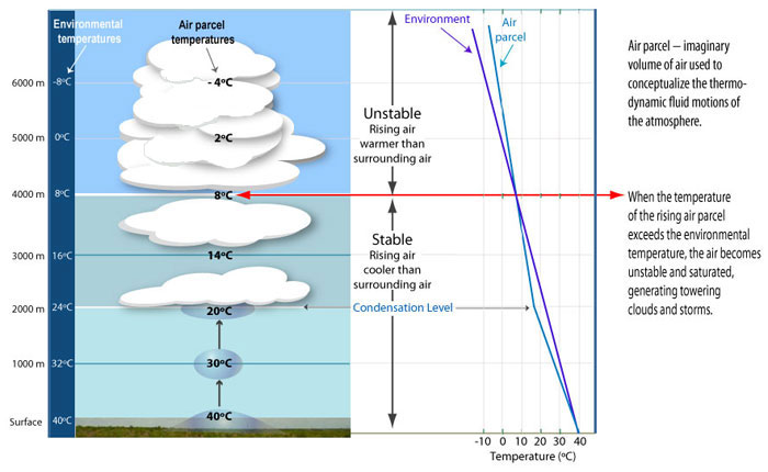
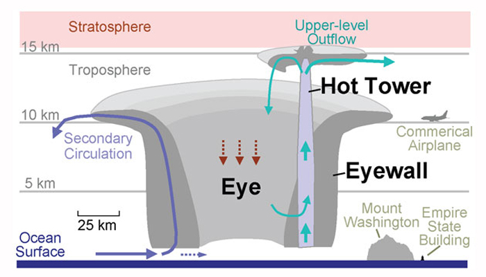
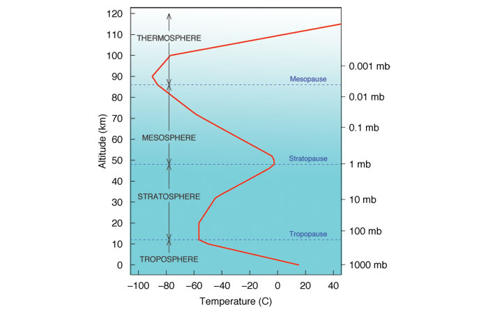
Now, a hurricane is also a heat engine. And the temperature at which the heat it put in is the temperature of the ocean, on the average about 86° Fahrenheit. So, in the case of a hurricane, it’s also an example of heat engine. The heat is put into the engine at the temperature of the ocean, the surface of the ocean, which is around 86° Fahrenheit, or maybe about 28° Celsius. And, the air flows up the eye wall of the hurricane, a ring of very strong thunderstorms that surrounds the eye. And then it goes out at the much higher altitude of the very upper part of the atmosphere where the temperatures are really, really cold. Some of the coldest temperatures you can find anywhere in the atmosphere, ironically, are in the tropics, about 10 miles, or 16 kilometers above the surface. And the temperatures are as low as -80°C, which is well below -100° Fahrenheit.
So there’s a big temperature difference acting across the hurricane. And for that reason, the hurricane is a fairly efficient heat engine, as natural heat engines go. You’re converting about a third of the heat energy you’re getting from the ocean into wind energy.
Interviewer: What is the ultimate source of the energy that drives this heat engine? How is it related to the greenhouse effect?
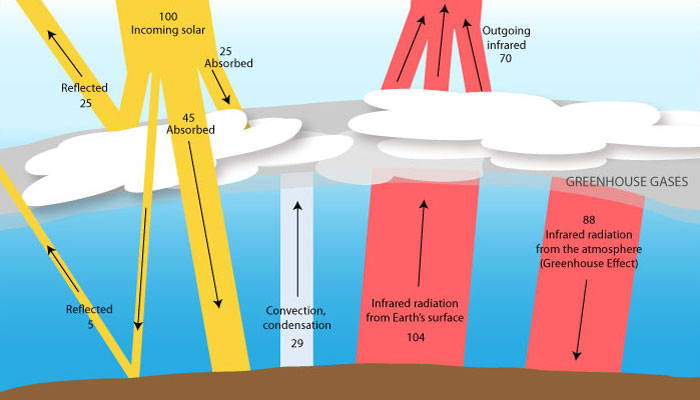
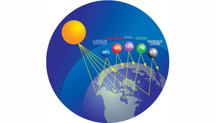
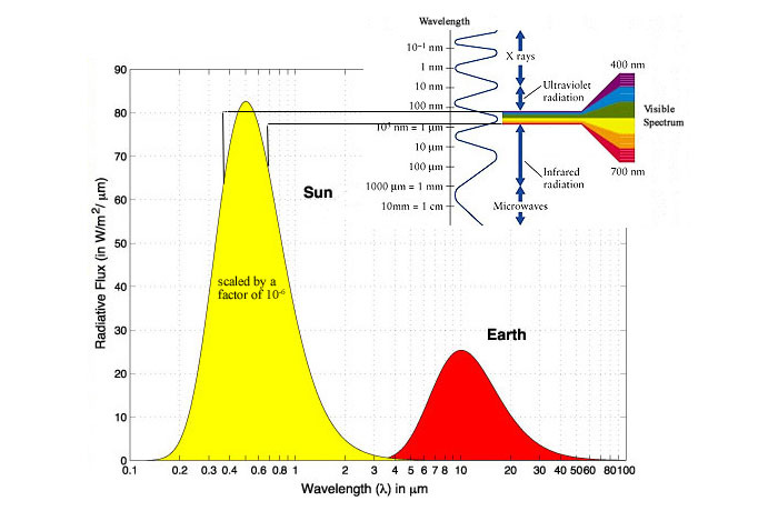
KERRY: The ultimate source of energy for everything, virtually, that happens in the atmosphere is the sun. And in fact, it’s the sun in combination with the greenhouse effect. And we would not have hurricanes were it not for the greenhouse effect, by the way. Here’s how it works. The sunlight heats the ocean. And if there were no atmosphere, the ocean would get rid of its heat simply by emitting radiation — it’s called “infrared radiation,” radiation you can’t see — back into space. And it would be a simple balance. That’s, for example, the balance that exists on the surface of the moon and the soil that’s facing the sunlight. And the moon has a certain temperature which you can easily calculate, so that’s it’s emitting just as much radiation as it’s getting from the sun.
But, the earth has this nice blanket of gasses around it. And some of those gasses are very important greenhouse gasses, water vapor being the most important, and also carbon dioxide, methane. And those gasses absorb some of the heat coming back up from the planet, and then re-radiate it back down to the surface.
And so, in the tropics, there is so much water vapor that the ocean finds it really can’t get rid of the heat it’s receiving from the sun by radiating it into space. So instead, the heat is carried away by currents of air. The air rising from near the ocean surface is a little bit warmer, and a lot moister than air coming down in downdrafts. So the air is carrying the heat away.
And for it to do that, the air in contact with the ocean has to be not saturated with water vapor. Its relative humidity has to be less than 100%, so that there’s a potential for evaporation. And it’s this potential for evaporation that drives hurricanes. It’s also why hurricanes tend to be most intense and frequent in the late summer and early fall when the ocean temperature is at its maximum and this disequilibrium between the ocean and the atmosphere is also at a maximum.
So if it weren’t for the greenhouse effect, we wouldn’t have a problem with hurricanes. One of the many things we’re worried about, if we should have any sort of global warming because the greenhouse effect is increasing, is that hurricanes might be a little bit more intense in a warmer world.
Interviewer: How do temperatures vary in a hurricane, vertically, from the ocean surface to the top?
KERRY: If you look at a photograph of a hurricane from space, what you see, of course, is this beautiful white spiral mass of clouds. It’s a little bit hard to tell, but those clouds extend from very close to the ocean surface up about ten miles high. And, the ocean surface is at a pretty high temperature. If anybody’s been to the tropics, they know that. It’s in the upper 80’s Fahrenheit, or 25° to 30° Centigrade. But the tops of the clouds in a hurricane represent the temperature that you find in the upper part of the atmosphere. It’s very, very cold. It’s around -80° Centigrade, or well below -100° Fahrenheit.
And, it’s something not too many people know about, the tropical atmosphere. It’s true everywhere in the atmosphere. It gets colder as you go up. That’s why there’s snow on top of Mt. Kilimanjaro, which is nearly at the Equator. But if you go very far up, way above the tops of mountains, it’s even colder. And, it can be very, very cold. So, the hurricane is operating across a rather spectacular gradient, from the ocean surface to the top of the storm.
Interviewer: Could you describe the process of hurricane formation?
KERRY: In fact, the generation of hurricanes, we call the “genesis of hurricanes,” remains one of the most enigmatic problems in atmospheric science. We don’t really understand how it works. But this is what we see when we look at things like satellite pictures, or sequences of pictures. Typically the first thing you see is a cluster of thunderstorms, or what we call “convective showers.” These are big cumuli nimbus clouds that are raining, very common in the tropics. And, usually they’re scattered, and they’re kind of disorganized.
And what you see is that they start to form clumps. And every once in a while, the clumps will begin to show some signs of rotation. And then, as time goes on, they get organized into kind of an anulus, a donut shaped ring of convection. And as the winds intensify at the surface, often an eye will develop, a clear region maybe 20 or 30 miles across in the center where the clouds go away, and you’re left with this much more organized, much more symmetrical mass of clouds.
Now, we understand that once this process gets underway, the feedback that allows the hurricane to grow is one between wind and evaporation. We just discussed a few minutes ago that the main source of energy for a hurricane is evaporation of water. But just as you feel colder when you get out of a swimming pool on a windy day than a calm day, the rate at which heat goes into the atmosphere is a function of the wind speed. The stronger the winds, the more heat you have.
So you have this loop. The stronger the hurricane winds, the more evaporation. The more evaporation, the more heat goes into the hurricane. The more heat goes into the hurricane, the stronger it gets. And that would just go on forever. But there’s one other thing that’s stopping it from doing that. It’s friction. And friction goes up even faster with the wind speed than the evaporation does. And eventually, it catches up. And at that point, the hurricane stops growing.
What is mysterious about this — I think we understand that process pretty well, by the way. — is how the whole thing got started. And, we know enough now to know that it doesn’t start spontaneously. That is, a butterfly flapping its wings somewhere in the western part of Africa is not capable of starting a hurricane. A hurricane is more like a lawnmower, in the sense that your lawnmower is sitting in the garage. It’s got perfectly nice gas in it. And everything is oiled. The spark plugs are good. But fortunately for you and for me, except maybe in horror films, the lawnmower does not just start spontaneously. You have to go over and the give the string a pretty good pull. And everybody who’s tried to do that knows that if your pull is too anemic, it doesn’t start.
Hurricanes are like that, too. You have to have some other kind of storm that has nothing to do with any of the physics we’ve been talking about, that comes along and gives a sufficiently strong push to the atmosphere. And, we understand why that’s true. But what we don’t understand is how it all manages to happen. And it’s rare, fortunately. It doesn’t happen all that often.
Interviewer: Tell us a little bit about some of the effects of a hurricane when it hits landfall. How would you know, if you were standing on the beach, that it was a hurricane, and not just a squall or something?
KERRY: Well, a hurricane is probably the most powerful storm on earth. The wind speeds are not quite as high as a tornado, but they’re much more extensive. A tornado covers a few hundred meters, whereas a hurricane spans many, many tens and hundreds of miles. And when a hurricane approaches the shore, there are all kinds of things that happen.
The first indication that something bad is happening out at sea are these terrific waves start coming ashore, long before there’s any wind. The waves typically outrun the hurricane. And, back in the old days, before we had satellites and aircraft, when we didn’t really know what was going on out in the sea, weather forecasters relied very heavily on this.
There’s the famous story of the Galveston hurricane that’s commemorated in this wonderful book called Isaac’s Storm about Isaac Cline, who was the meteorologist on duty in Galveston in 1900. And, although he had reports from Cuba that there was a hurricane there, they had no way of really knowing whether it was coming into the Gulf of Mexico. The first time he really got suspicious is when these enormous swells began to roll in to the beaches of Galveston. And he started to think, “Oh my goodness. Something is going to happen.” So that’s the first thing that happens.
Then of course, the sky out to sea turns very dark, as the central mass of clouds approaches the shore. The wind gradually increases. It’s not usually a very sudden increase of wind. You start to get rain squalls, the spiral bands of the hurricanes. So the rain comes and goes, and the wind gradually increases.
And then as the eye wall approaches the shore, the winds start to increase very, very fast, and particularly if the hurricane is moving fast. And the other thing that happens is, of course, the waves get bigger and bigger. But the waves are superimposed on another phenomenon that we call the “storm surge,” which is a general elevation of the water, which is caused by the net effect of the winds pushing all this water in to shore.
And there’s another small contribution just from the fact that the pressure in the center of the hurricane is very low. It actually pulls the ocean surface up a little bit. So this big wall of water comes in. And, it can be 20, 30 feet high in extreme cases. And historically, it’s this storm surge that has killed the most people, and, in many storms, does the most damage.
The other phenomenon that many people are not familiar with is the enormous amounts of spray that are lofted into the air in a hurricane. When the winds start to flow more than about 80 or 90 miles per hour, so much spray is lofted into the air that, eventually, it becomes hard to even talk about the surface of the ocean. And I’m not speaking metaphorically. You just go from air which is filled with bubbles to– water which is filled with bubbles to air which is filled with spray gradually. And there’s no longer anything you can call the surface of the ocean. So it becomes a real chaos in the core of a hurricane.
Interviewer: What about the eye of the hurricane?
KERRY: Well of course, there’s a lot of lore about the eye. And, visually, the eye is the most spectacular place to be, particularly if you’re in an airplane. What happens is, just as the winds reach their most ferocious state, they will quite suddenly start to decline. And, in a very, very intense storm like Hurricane Andrew, that decline can be very rapid. Almost in a few minutes, the wind just drops off. The skies may clear. Although usually, there’s a lot of low clouds around. You can sort of see the sun now and then peeking through the clouds, which is too bad. Because if it weren’t for the low clouds, you could see this wall of clouds that just went over you, and it would be very spectacular looking. I know because I’ve seen it from an airplane.
The winds drop off. And in the old days before people really even understood hurricanes were rotary storms, a lot of people got killed because they thought the storm was over. So they went out, and they tried to start picking up after all the damage, only to be hit by the other side of the storm. Today, most people understand that and that doesn’t happen.
But there are all sorts of other crazy things that happen in the eye. Birds at sea will sometimes get trapped in the eye. And, because it’s so violent in the eye wall, they really can’t get out. And if the hurricane goes to very high latitudes, it takes all these tropical birds with them. So that every once in a while, some tropical species of bird will show up in Newfoundland or someplace.
And if a ship happens to mistakenly get caught in the eye of a storm, which doesn’t happen very much anymore because of the good warnings they get, then these birds — exhausted birds — will land on masts on the ship. There are photographs of these tankers in the eyes of hurricanes completely covered with birds that were trying to get a rest.
Interviewer: How would can you predict the intensity of a hurricane as it evolves?
KERRY: Well, when we first started to look at this whole business of treating the hurricanes as systems, one of the things that came immediately out of that was that we realized that for a given atmospheric environment, in a given ocean temperature, there was a maximum wind speed that you could achieve in a hurricane, which we can easily calculate if we only know the sort of average properties of the tropical atmosphere in the ocean. It’s a speed limit.
And, in some sense, it works very well. That is, if you look at the actual observed wind speeds in lots and lots of different hurricanes, and you compare those wind speeds to this limit, indeed, no storm ever exceeds this limit. And only a very small percentage of them actually come right up to the limit. Most of them fall far short.
One of the interesting things that happened to us when we did this is we started to build computer models of hurricanes. And, in fact, I have such a model that I distribute freely to teachers that can be run on an ordinary personal computer. [See: http://wind.mit.edu/~emanuel/home.html ] And, the computer models behaved, in some ways, very differently from real hurricanes in that they always spun up to their speed limit, unless something really terrible happened to them, like they went onshore.
We didn’t understand that at first. The ideal computer hurricanes always reach their speed limit. But the real ones seldom made it. Even if you look at the real hurricanes that stay over warm tropical water, and don’t make landfall, they don’t usually reach the limit either. And, we started to ask why. One of the first things that occurred to us is that in the idealized models, we hold the ocean temperature fixed. We don’t let it change. It’s just whatever it is.
But a real hurricane profoundly changes the temperature of the sea water, not because it’s taking heat out of the ocean. It is doing that and that does cool the water. But it’s maybe a tenth of a degree or so. It’s not really noticeable because it’s such a huge heat reservoir. What the real hurricanes do is they churn up the ocean. And you don’t have to go very far down in the tropical ocean before you find very cold water. It’s only hot right within the first hundred feet or so of the surface.
The hurricanes come along, and they mix this cold water up to the surface. You can look at a satellite picture and see these really cold wakes that are left behind by hurricanes. And so the hurricane is cooling off the ocean temperature. And it would only have to cool it off about 2?° Celsius right under the eye wall to kill the hurricane. So even a 1° drop is important.
We’ve learned how to include that effect in the computer models, including the simple one that anybody can run. We have a way of dealing with that now which, indeed, predicts that most hurricanes don’t really come up to the speed limit.
Interviewer: Do hurricanes ever get close to their theoretical maximum speed limit?
KERRY: It’s only in very exceptional circumstances they do. One famous case is Hurricane Camille, which was one of the most violent hurricanes every to strike the U.S. in history.
In 1969, it came roaring up the eastern side of the Gulf. And it smashed into Mississippi with winds of something like 200 miles per hour. This was a bit strange because in the Gulf of Mexico, the layer of warm water, most of the time, is very, very thin. It’s 20 or 30 meters deep. And normally, a hurricane would just never get that intense.
But, there is a phenomenon in the Gulf of Mexico called a “loop current,” which is a narrow current of very hot water that runs very deep. It’s called a loop current because it comes up through the Yucatan passage right up toward New Orleans. And then it just does a U-turn, comes down just off the west coast of Florida, goes through the Straits of Florida, and becomes the Gulf Stream. So it’s a predecessor of the Gulf Stream.
And we figured out that what happened with Camille is that by sheer accident, Camille went right up the center of this loop current where the warm water runs very, very deep. And so there wasn’t any cold water to churn up. It didn’t have this negative influence. And it just really went to town. But there are other things as well.
One of the most mysterious things is the interaction of hurricanes with other weather systems, particularly if the atmosphere has what we call, “wind sheer,” where the background winds, the everyday normal wind that you have in the atmosphere, is changing with height, either direction and/or speed. When hurricanes move into environments in which this background wind is changing with height, they often weaken. And that’s observed so often that there can be little doubt of it. But we don’t really understand the mechanism very well. There’s all kinds of speculation.
All of this has led to the problem that we’re really not very good at forecasting hurricane intensity change. We can forecast where it will go pretty well compared to a lot of other things we do. But the intensity change is just not very good at all. So there’s a long way to go in understanding how storms interact both with their atmospheric environment and with the ocean.
Interviewer: Can you describe some of the current cutting edge research that you’re doing now, and why it’s important to people?
KERRY: We’re working on several facets of hurricane behavior that range from the microscopic all the way up to global. Starting in the microscopic end, if you want to predict hurricane wind speeds, you have to know how the transfer of heat through the ocean surface, the evaporation, depends on wind speed. And we know how it does at low wind speeds, but we don’t really understand, nor do we have measurements of, what happens at high wind speed.
The other thing you have to be able to do is to predict the drag that ocean exerts on the air. And again, we know how to predict that at low wind speed. But, at high wind speeds, we would have these gigantic waves. We don’t know how to do that. Everything we know so far teaches us that the major piece of physics that has to be understood to do this correctly at hurricane wind speeds is sea spray.
Sea spray, we think, is fundamental to a hurricane. When a spray droplet goes up and partially evaporates, it gets very cold. It comes back down to the ocean. It turns out that process transfers an enormous amount of heat to the air. And so sea spray is a very efficient heat transfer mechanism.
But when a spray drop goes up into the air, it has to accelerate to the wind speed. And in doing so, it exerts a drag on the air. So it’s also a major sink of wind energy for a hurricane. And so we have built a laboratory apparatus in which we can simulate these very fantastic conditions, very high wind speeds, air blowing across water. The air is filled with spray. We’re trying to carefully measure the friction and the heat transfer of the spray.
Now to jump to the completely opposite end of the spectrum, people have worried for some years about whether climate change affects hurricane activity. Were there more or fewer hurricanes during that last Ice Age, for example. Will there be more or fewer hurricanes if we have global warming? But very few people have asked the question, “Do hurricanes play some central role in the climate?” We tend to think of them as freak storms that don’t really affect the climate in an important way.
Text books, by the way, are full of bad information about this; hurricanes transfer lots of water from the tropics to the Pole. It’s just not true. They’re minor players in the water budget of the earth. But, there’s something rather unexpected that’s turned up from research – that hurricanes may have a profound effect on the global circulation of the ocean.
The ocean works in a very different way from the atmosphere. But, here’s what we know. Of all the heat that gets transported by both the ocean and the atmosphere from the tropics toward the Poles, on average about a third of it is transported by the ocean, and about two-thirds by the atmosphere. And so the climate would be very different if the ocean weren’t transporting all this heat.
There is a lot of argument about how this works. One of the theories that’s being kicked around in very recent days is that, oddly enough, it’s hurricanes that allow this to happen. And the reasons are very subtle. But it was actually proved about a hundred years ago that the only way you could make the ocean transport a lot of heat from the tropics to the Pole is if you could turbulently mix hot water in the tropics down into the deep tropical ocean.
Oceanographers have argued for years about what’s doing this mixing. We’ve done some calculations that suggest that global tropical cyclone activity (tropical cyclone is a generic name for a hurricane) is what’s doing this mixing. Now if this is true, it means that we have to completely rethink our understanding of how the climate works in general. Because in the big huge computer models that are used to simulate climate, this mixing is just specified. It’s constant. It doesn’t change with time or climate. It’s specified out of ignorance. We don’t know what else to do.
If it’s hurricanes that are driving this mixing, we have a different problem all together. We have a different system dynamic because the hurricanes themselves are functions of the climate. And so, we have built some simple models in which we allow the climate to control the hurricanes, and the hurricanes to control the heat flux in the ocean. And we get some very interesting behavior that may explain things, for example, like the climate 50 million years ago when the tropics were about the same temperature they are today but the poles were much warmer. Instead of being around 0° Centigrade, they were something closer to 15 or even 20°.
This is when there were crocodiles wandering around Greenland, and alligators in London, and places like that. And this is a great mystery because the distribution of sunlight over the earth was not appreciably different in those days. But we think it was a very stormy climate with a lot of hurricanes, which was driving a fantastic polar heat flux in the ocean that was responsible both for keeping the tropics relatively cool, and for keeping the high latitudes warm.
This is a new branch of research that now ties hurricanes into the whole climate system in a way that might prove to be very interesting.
Interviewer: As you’ve worked on this, have you had your view of the earth’s circulation system become more of a bird’s eye view rather than a microscopic view?
KERRY: I think it’s worked in both directions. For me, since I’ve been in this field, which is well over 20 years, I came from a fairly narrow perspective of trying to understand a few types of systems we see in the atmosphere. But, that understanding has led — or the attempt to achieve such an understanding has led — both downscale and upscale. On the one hand, we’re forced to study what we call, “microscopic processes,” like how does a drop of spray form and break off, and what laws govern that, down to this whole global thing of how is everything interconnected in a way that controls the climate?
And understanding climate is a really fascinating issue. It’s a young science. But in the last decade or two, all of these ice cores and deep sea sediments have provided this marvelous record of climate that shows a very, very unusual and dynamic system that we only are beginning to understand. So for anybody starting out in science, this is a fantastic place to go and make discoveries.
Interviewer: Is there anything that you wanted to add that we didn’t ask you?
KERRY: There’s one other interesting branch of research that may help us understand the relationship between hurricanes and climate. It’s what’s called paleotempestology. That’s an effort to reconstruct a very long-term record of storminess from the geological record. There are several techniques, and one which I’m familiar with involves going to lakes [or lagoons that are near the shore] but that are separated from the ocean by a sandbar. There are lots of those along the U.S. Gulf Coast and the East Coast.
The nature of these lakes is such that when a hurricane does come, and there’s a direct hit, the storm surge washes over the sandbar into the lake, carrying with it a lot of sand. And so a layer of sand is deposited at the bottom of the lake. Now, the rest of the time, when there’s no storm, it’s just mud that’s building up, organic deposition, plants, decaying plants and things.
If you go into the lake with a boat and you drill down into the lake bottom, and you take a core up and you look at that core, what you see is a lot of black mud with some intervening layers of sand. Those layers of sand represent hurricane strikes. You can use a technique that has to do with the radioactive decay of certain isotopes and this organic matter to date it, so you can find out when those sand layers were put down.
People have gone back in time now about 4000 years with this technique. There are certain places along the Gulf Coast where we now have something like a 4000 year record of hurricane activity, which is fantastic. One of the things we see consistently is that the period between about 1000 years ago and 3000 years ago was very active compared to today. There were a lot more hurricanes than there have been in the last 1000 years.
During the period before about 3000 years ago there were very few storms. So we had very few, then we had lots. And then in the last 1000 years, we had few in that part of the world. If that same kind of thing can be done all over the place, we could build up quite a long-term record of hurricane activity. And that would be a step toward understanding what controls the level of hurricane activity.