
American Passages: A Literary Survey
Exploring Borderlands Samuel de Champlain (c. 1570-1635)

[2846] Samuel de Champlain, Illustration from Les Voyages du Sieur de Champlain Capitaine Ordinaire pour Le Roy en la Nouvelle France es Années 1615 et 1618 (1619), courtesy of the Robert Dechert Collection, Annenberg Rare Book and Manuscript Library, University of Pennsylvania.
Champlain was soon appointed lieutenant general of the colony. Hoping to further French land claims and commercial interests, he sent delegates to explore as far west as the Great Lakes region. His scouts learned Native American customs and languages and established friendly relations with the Huron and Montagnais Indians in particular. The French eventually joined with these Indian allies to fight their traditional enemy, the Iroquois, in sustained conflict. Champlain recorded his experiences in New France in four books, which combine illustrations, maps, personal narrative, geographical and natural description, history, and ethnographic insights into Native American life. His combination of pictorial and verbal description lends his work an unusually vivid quality that literary critic Gordon Sayre has described as a “distinctive narrative story-board effect.”
In 1629, invading British troops unexpectedly captured Quebec and Champlain was taken to England as a prisoner. When a diplomatic treaty returned Canada to the French in 1632, Champlain was reinstalled as lieutenant general. He died three years later in Quebec on Christmas Day.
Teaching Tips
- Ask your students to pay close attention to the incident in Chapter VIII of The Voyages of Sieur de Champlain in which French sailors and Indians have a violent skirmish over possession of some large iron kettles. In this passage, Champlain narrates the way cultural misunderstandings and the ill-considered actions of a few individuals can ignite destructive, large-scale confrontations. Have your students outline the progression of events and the actions that lead to the escalation of the fight. Who are the principal actors? What motivates them? What kinds of communication difficulties cause and exacerbate the situation? How do the French and Indian leaders ultimately diffuse the tension? Is the situation resolved satisfactorily for all parties? It might be useful to ask your students to compare Champlain’s account of this encounter with some English and Spanish narratives of violent confrontations with Native Americans (William Bradford, John Smith, Christopher Columbus, or Bernal Díaz del Castillo, for example).
- In Cartography in Prehistoric, Ancient, and Medieval Europe and the Mediterranean, J. Brian Harley and David Woodward argue that “maps are graphic representations that facilitate a spatial under-standing of things, concepts, conditions, processes, or events in the human world.” Have your students examine Champlain’s “Map of New France,” which is featured in the archive. How does this map help facilitate Champlain’s view of New France and the Americas more generally? What key concepts and processes are represented in Champlain’s map? You might call attention to details such as how he pictorially represents the landscape and the relative scale of the various pictures. How does Champlain depict Native Americans? Plants and animals? Natural resources? Europeans? How does the map differ from current maps? After you have discussed Champlain’s map, ask your students to borrow his techniques to produce a map of their own city, their neighborhood, or an area they have visited recently. Discuss their maps as a class.
Author Questions
- Comprehension: What kinds of misunderstandings and disagreements do Champlain and his party have with the Native Americans they encounter? How do they communicate? What kind of strategies do they use to diffuse tension?
- Context: In Chapter VIII of The Voyages of Sieur de Champlain, Champlain describes the problems he has communicating with Native Americans. He finds that he cannot get answers to questions because “we did not understand their language, although they attempted to explain by signs.” Later, he credits Etienne Brulé for his skill as both a cultural and a linguistic interpreter between the Indians and the French. John Smith, on the other hand, never mentions the language barrier that must have complicated his dealings with the Native Americans in Virginia, nor does he mention the presence of interpreters. Why might Champlain and Smith have narrated their encounters with Native American languages so differently? How do their different accounts of linguistic communication shape their descriptions of their own positions within Native American communities?
- Context: How does Champlain’s concern with developing the fur trade compare to the Spanish explorers’ interest in finding gold and setting up encomiendas in America? How might the differences in the production, trade, and value of these different commodities have led to substantive differences between the French and the Spanish settlements?
- Context: How does Etienne Brulé survive the hostile Indians who torture him and are “prepared to put him to death”? Does Champlain’s narrative of Brulé’s “miraculous” escape describe divine intervention, or is he implying that Brulé simply benefited from a fortuitously timed thunderstorm? How does Champlain’s narration of the role of prayer and religious icons in French interactions with natives compare to Columbus’s or Díaz del Castillo’s descriptions of Spanish religious practices during the Conquest?
- Exploration: Both Champlain and William Bradford narrated their contact experiences with Native Americans on the coast of present-day Massachusetts. How do their accounts differ? What do they have in common? How do their descriptions of the coastal landscape and the area’s natural resources compare?
- Exploration: To what extent is the history of New France important for understanding American colonial history? Why do you think Champlain’s voyages were not depicted in one of the four scenes of U.S. discovery in the Capitol Rotunda? (The four scenes are of Columbus, de Soto, Pocahontas, and the Pilgrims, and they date from the 1840s to 1850s.) Would Champlain’s voyages be included today if the Rotunda paintings were replaced?
Selected Archive Items
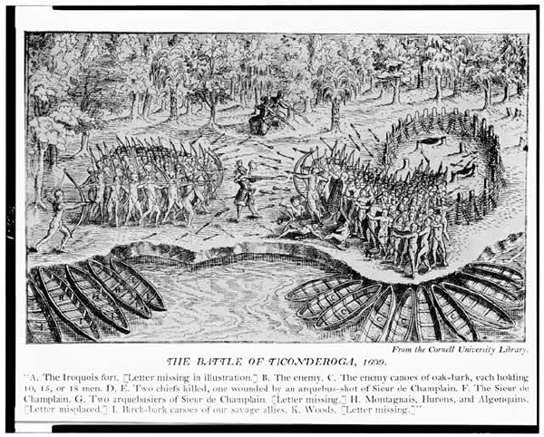
[1365] Anonymous, The Battle of Ticonderoga (1609),
courtesy of the Library of Congress [LC-USZ62- 108526].
This illustration depicts the French explorer Samuel de Champlain and his Native American allies fighting the Iroquois on the Ticonderoga Peninsula in 1609. As seen in the illustration, Champlain’s mechanical firearms overpowered the Iroquois.
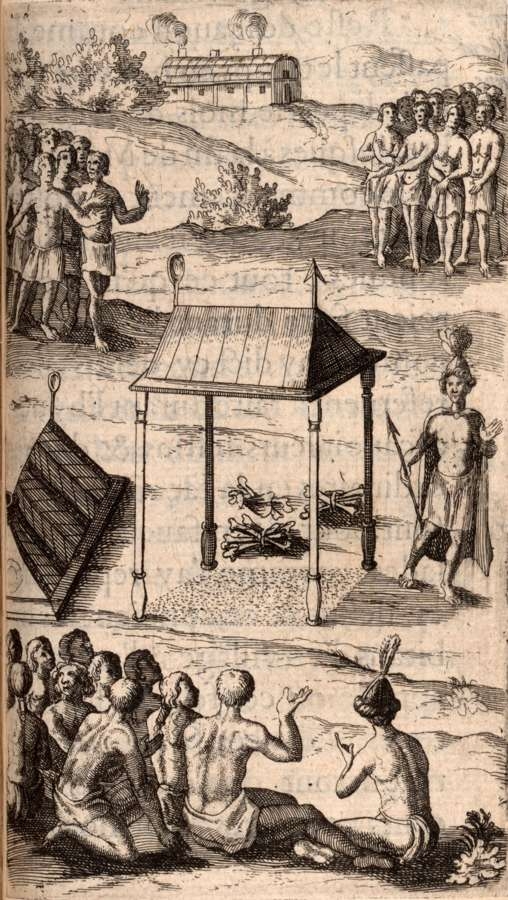
[2846] Samuel de Champlain, Illustration from Les Voyages du Sieur de Champlain Capitaine Ordinaire pour Le Roy en la Nouvelle France en Années 1615 et 1618 (1619),
courtesy of the Robert Dechert Collection, Annenberg Rare Book and Manuscript Library, University of Pennsylvania.
This engraving, made during one of Champlain’s voyages, shows Huron funerary practices.
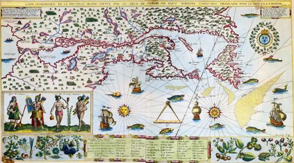
[2869] Samuel de Champlain, Carte Geographique de la Nouvelle Franse . . . Faict Len 1612(1612),
courtesy of the Osher Map Library, University of Southern Maine.
Samuel de Champlain mapped the region from the St. Lawrence Valley through the Georgian Bay and Lake Ontario and along the Atlantic coast to Cape Cod between 1603 and 1616. This map, which uses Native American mapping techniques, shows Lake Ontario and Niagara Falls.
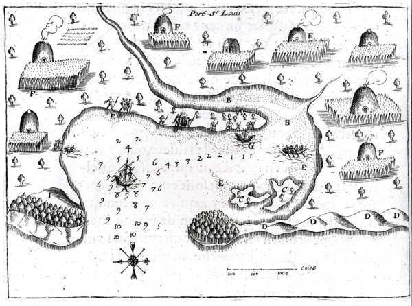
[3191] Samuel de Champlain, Sketch of Wampanoag Wigwams at Plymouth (1605),
courtesy of the John Carter Brown Library, Brown University.
The Wampanoag, meaning “Eastern people,” probably numbered around 12,000 just before contact. They lived in small bands in beehive-shaped huts loosely clustered into villages, as shown in this sketch. English settlers in the Plymouth colony originally modeled their dwellings after these highly efficient native homes but soon abandoned them in favor of more “proper” British-style housing.