


Art Through Time: A Global View
The Urban Experience Art: Benjamin Franklin Parkway
» Paul Philippe Cret (French, 1876–1945) and Jacques Greber (French, 1882–1962) (designers)

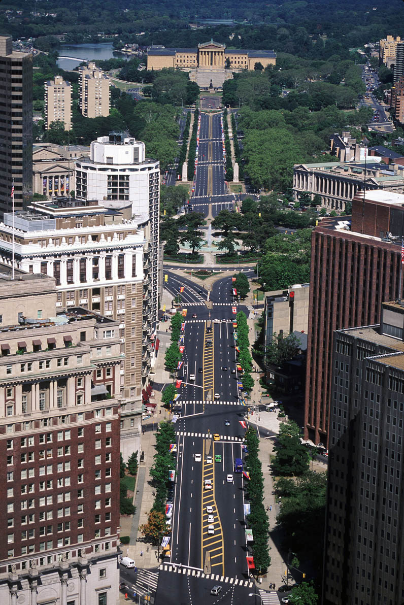
Benjamin Franklin Parkway
Artist / Origin: Paul Philippe Cret (French, 1876–1945) and Jacques Greber (French, 1882–1962) (designers)
Region: North America
Date: 1917–1926
Period: 1900 CE – 2010 CE
Material: Pavement and trees
Medium: Architecture and Planning
Dimensions: L: approx. 1 mi. (1.6 km.)
Location: Philadelphia, PA
Credit: © Alan Schein Photography/CORBIS
The City Beautiful movement arose around the end of the nineteenth century in America.
As reformers in other sectors of society sought to improve the conditions of America’s increasingly poor, crowded, and dirty urban centers through social programs, sanitation initiatives, and the law, the designers of the City Beautiful movement looked to urban planning and architecture for solutions. Beautification of the urban environment, they asserted, would inspire civic loyalty and moral virtue in the city’s inhabitants. It would, moreover, encourage upper-class visitation and spending, while fostering national pride through cities that could compete with the great metropolises of Europe. One of the most important precedents for City Beautiful planners was the Champs-Elysées in Paris, a broad boulevard that served as the model for similar designs in cities across the United States, including Philadelphia’s Benjamin Franklin Parkway.
Philadelphia’s original plan, laid out by William Penn in the seventeenth century, took the form of a regular, rectangular grid; the Parkway cuts a swath across an entire section of that grid. Stretching just over a mile long, it runs between City Hall and the entrance to Fairmount Park, Philadelphia’s extensive park system. True to its City Beautiful ideals, the elegant, tree-lined Parkway not only brings a slice of nature to the city, but also serves as a focal point for art, culture, and learning. The dramatic terminus of the Parkway is the Philadelphia Museum of Art, a majestic example of Greek revival architecture. Other major buildings and institutions, including the Free Library, the Academy of Natural Sciences, and the Cathedral of Saints Peter and Paul, are situated along the length of the Parkway, while greenery, monuments, and grand fountains ornament the islands that punctuate its central axis.
Expert Perspective:
David B. Brownlee, Professor of Art History, University of Pennsylvania
“Philadelphia was laid out by its founder, William Penn, with the help of a surveyor by the name of Thomas Holme in 1683 as a grid plan city—a city that was regular and orderly, as the cities William Penn knew growing up were not, and a city that he imagined would be immune to the destructive fires that destroyed, well, in fact, that destroyed the city of London in 1666. This would be an orderly and regulated world. He laid out enormous city blocks. They were so big because he intended that there would be no row houses. That each individual homeowner would build a house, surrounded by trees, in what he called a ‘green country town.’
The settlers who came to Philadelphia did not buy into his vision, and they settled on this great grid plan only reluctantly. They built houses cheek by jowl up against each other. They cut narrow alley ways through the gigantic blocks that he imagined would be orchard-filled and built a tangled mass of small houses and courtyards, just like the medieval cities that they had left—the medieval cities that for them represented civilization, that they wanted to recreate on this side of the Atlantic.
At the time of the Declaration of Independence, probably only an eighth of the city had been built upon, but over the next two centuries, the plan was completely filled out. The idea of the grid plan prevailed. But in the nineteenth century, the city of Philadelphia also created the great antithesis of this infinitely expanded grid plan. They annexed and preserved gigantic tract of natural land that they converted into Fairmount Park. The world’s largest park associated cheek by jowl with this gigantic grid-planned industrial city.
Throughout the last years of the nineteenth century, Philadelphians struggled with the idea of connecting these two things—the grid plan city and the largest park in the world. And out of this came a genuine metropolitan consensus that what was needed was a great roadway, a great roadway that would connect the city to the park. And in the early twentieth century, with demolition beginning in 1907, the city seemed to disembowel itself by cutting a great boulevard from City Hall diagonally north westward to Fairmount Park. That Fairmount Parkway, renamed in honor of Benjamin Franklin in the 1930s, was conceived in some respects, very like the boulevards that Haussmann cut through Paris in the 1850s and 1860s, and it is a connection between two different worlds—a bridge between the natural and the man-made.”
Additional Resources
Brownlee, David. Building the City Beautiful: The Benjamin Franklin Parkway and the Philadelphia Museum of Art. Philadelphia: The Philadelphia Museum of Art, 1989.
“City Planning, the Fairmount Parkway, and the Free Library of Philadelphia.” In Celebrating 75 Years on the Parkway. The Free Library of Philadelphia Web site. http://libwww.freelibrary.org/75th.
The Parkway Council Foundation Web site. http://www.parkwaycouncilfoundation.org.
Sies, Mary Corbin, and Christopher Silver, eds. Planning the Twentieth-Century American City. Baltimore: The Johns Hopkins University Press, 1996.
Wilson, William H. The City Beautiful Movement (Creating the North American Landscape). Baltimore: The Johns Hopkins University Press, 1994.