Social Studies in Action: A Teaching Practices Library, K-12
China Through Mapping
Mimi Norton teaches second grade at Solano Elementary School in Phoenix, Arizona. In this lesson, students learn about China's position on the globe and the location of important landmarks within the country. As a class, students create a giant map of China on the floor. Working in teams, students complete mapping tasks at classroom stations, focusing on the five themes of geography. As a culminating activity, students solve an interactive detective mystery created by Ms. Norton and work in small groups to solve problems based on their mastery of the map of China.
Video Summary: In this lesson, Mimi Norton integrates world geography with the study of Chinese culture and history by engaging her young students in a variety of activities to locate natural and human-made landmarks on maps of China. To build background for this lesson, she has had the students create salt-dough maps of China and label them with map symbols.
Ms. Norton begins the lesson by reviewing map symbols with students and having them use the symbols to locate important natural and human-made land forms on desk maps. Then the class sings a song about the continents and oceans and locates them on a floor map. Ms. Norton explains that they will use what they are learning about scale in math class to enlarge a small map of China to room size. To do this, Ms. Norton first draws a large grid on the floor. Then she hands out cards, each representing a small section of China. Students then copy the information on their card to the corresponding square on the floor grid. The result is a large floor map of China. After the map has been drawn, students label the natural and human-made features at the correct locations on the map. Ms. Norton reads a story about a fictitious traveler in China and has students trace the traveler’s journey. As a culminating activity, students don a Chinese dragon costume and walk to famous locations on the map.
Class at a Glance
- Teacher: Mimi Norton
- Grade: 2
- School: Solano Elementary School
- Location: Phoenix, Arizona
Themes and Standards Addressed in This Lesson
“China Through Mapping” highlights the following NCSS standards-based themes:
- Culture
- Time, Continuity, and Change
- People, Places, and Environments
- Global Connections
Content Standards:
- Geography
- History
About the Class - Classroom Profile
 “I think geography and social studies come alive when you put a face on them, when you meet the people who are there. They’ll never forget the Chinese people, because we’ve watched them, we’ve learned about them, we’ve made things that they’ve used. And I think that brings it to life for them.”
— Mimi Norton
![]() Mimi Norton teaches second-grade social studies at Solano Elementary School in Phoenix, Arizona. Four hours south of the Grand Canyon, Phoenix is one of the fastest-growing cities in America. The rural farmland and desert that Ms. Norton remembers from growing up in Phoenix has been replaced by a sprawling downtown and new residential and commercial developments.
Mimi Norton teaches second-grade social studies at Solano Elementary School in Phoenix, Arizona. Four hours south of the Grand Canyon, Phoenix is one of the fastest-growing cities in America. The rural farmland and desert that Ms. Norton remembers from growing up in Phoenix has been replaced by a sprawling downtown and new residential and commercial developments.
Solano Elementary School is located in downtown Phoenix and reflects the city’s ethnic diversity. Roughly 85 percent of the students are minorities — predominantly African American, Native American, Hispanic, and Bosnian; some are recent immigrants. Most families live in subsidized housing. All qualify for free or reduced lunch, and the school provides uniforms for its students. The school’s population tends to be very transient, with students moving and transferring schools several times during the year.
Year at a Glance
Units in Mimi Norton’s Social Studies Year
- Five Themes of Geography
- China
- Africa
- African-American History
- Economics
- Social and Political Literacy
Ms. Norton started the year with a unit on the five themes of geography, combining the district guidelines with units from National Geographic. Students were introduced to the vocabulary of geography, the globe as a model of the earth, maps and map symbols, climate, terrain, plants and animals in different geographic regions, and movement, to name just a few of the topics covered in the unit. Ms. Norton used geography as a unifying theme throughout the year, introducing each new region by having students first examine its geography.
By the time the class began the unit on China, Ms. Norton wanted students to understand that the Earth’s surface features vary from place to place and that maps are diagrams that use symbols to represent the locations of places and things in relation to other places and things. She also wanted students to understand the relationship between people and the environment, that structures like the Great Wall are erected for a purpose, and that there is a connection between themselves and people of different cultures.
In the lesson “China Through Mapping,” Ms. Norton relied heavily on her own experience as a 1999 Fulbright fellow in China. She had her students explore natural and human-made landforms in China and how China’s culture and history is shaped in part by its geographic location and features. Subsequent lessons in the China unit covered movement and transportation, more about the nation’s culture and history, famous people and places, and Chinese inventions. After the unit on China, the class went on to study Africa and African American history.
About the Class - Lesson Background
Read this information to better understand the lesson shown in the video.
Content: Learning About China Through Geography
China is the world’s most populous nation. Occupying nearly one-fourth of the Earth’s land area, it is also one of the largest (behind only Russia and Canada). China can be divided into three main geographic zones: the eastern zone with its vast plains and rivers, the arid northwestern zone, and the mountainous southwestern zone. The following are some of the geographic landmarks featured in this lesson:
 Taiwan is an island located 100 miles off the southern coast of China. Forced from the mainland in 1949 by occupying communist armies, the Nationalist government of China sought refuge in the island’s main city of Taipei, making it the seat of government of the Republic of China. The island is heavily populated, and people live mainly along the coastal plain or on the western side of the island. Volcanic mountain ranges are found in the eastern part of Taiwan.
Hong Kong, located on the southern coast of mainland China, was a British Crown Colony following World War II until 1997, when it reverted back to Chinese control. With a large population and little arable land, Hong Kong has become one of the world’s largest banking centers.
The Yellow River (Huang He), the Yangtze River (Chang Jiang), and the Xi River (Si Kiang) are prone to flooding but also provide fertile soil for agriculture. Population concentrations are found in the valleys along these rivers.
The Great Wall of China is the only human-made structure that can be seen from space. Ranging from 20 to 50 feet in height and stretching for 1,500 miles, the earth and stone wall is located along the Mongolian Plateau in northern China. The earliest part of the wall was built in the third century to protect against invasion from the north. Gates built into the wall, especially those located in the city of Beijing (Peking), became centers of trade.
The Gobi Desert extends from the north-central China border into Mongolia. Europeans first learned of the Gobi from Marco Polo’s travels during the thirteenth century. As Asia’s largest desert, it represents another geographic barrier.
The Himalayas are on the border between Nepal and China and are home to the world’s highest peak, 29,035-foot Mount Everest. Geologists believe the Himalayas were formed when two continents collided.
The Kunlun Mountains are north and east of the Himalayas. The Kunlun range is one of the highest in the world.
The Plateau of Tibet is located in southwest China, between the Himalayas and the Kunlun Mountains. At 13,000 feet above sea level, it is the highest plateau in the world. Cold and inhospitable to early settlement, it lies in the Tibet Autonomous Region and the Tsinghai Region.
Teaching Strategy: Integrating Social Studies with Other Curriculum Areas
A position statement by the National Council for the Social Studies regarding students in early childhood and elementary grades states that:
Basic skills of reading, writing, and computing are necessary but not sufficient to participate or even survive in a world demanding independent and cooperative problem solving to address complex social, economic, ethical, and personal concerns. Knowledge, skills, and attitudes necessary for informed and thoughtful participation in society require a systematically developed program focusing on concepts from history and the social sciences.
Using content and skills from a variety of subjects to enhance your social studies curriculum not only encourages students to explore a topic from different angles, it helps reinforce what they have already learned. For example, students apply their newly acquired map skills to learn about the history and culture of China, and read books that enhance what they are learning about the culture and traditions of China. Information presented from a variety of subject areas allows students to relate to content from other academic perspectives, and underscores the connection between subjects.
Watching the Video
Notes
As you reflect on these questions, write down your responses or discuss them as a group.
Before You Watch
Respond to the following questions:
- What are some important elements of geography and culture that young students need to understand?
- What issues do you consider when planning a lesson that integrates content and skills across curriculum areas?
- What does a teacher need to consider before asking young students to work in groups?
Watch the Video
As you watch “China Through Mapping,” take notes on Ms. Norton’s instructional strategies, particularly the way she integrates other curriculum areas with social studies. Write down what you find interesting, surprising, or especially important about the teaching and learning in this lesson.
Reflecting on the Video
Review your notes, then respond to the following questions:
- What struck you about the classroom climate, background, preparation, strategies, and materials used in this lesson?
- How is this class different from yours? How would you introduce elements of China’s geography and culture to your students?
- What role do previous lessons and experiences play in the success of this lesson?
- What does Ms. Norton do to ensure students’ success working in pairs or groups?
- What do you notice about how Ms. Norton integrates other subject areas with her social studies curriculum? Do certain subject areas lend themselves better to integration than others?
- How does Ms. Norton assess students’ understanding of abstract geography and mapping concepts?
Looking Closer
Let’s take a second look at Ms. Norton’s class to focus on specific teaching strategies. Use the video images below to locate where to begin viewing.
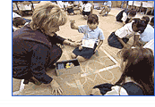
Active Learning About China: Video Segment
 Go to this segment in the video by matching the image (to the left) on your video screen. You’ll find this segment approximately 1 minute into the video. Watch for about 5 minutes.
Ms. Norton uses a variety of experiences to help introduce students to the culture and geography of China. In this part of the video, Ms. Norton is reviewing map skills with students.
- What evidence do you see that students are engaged in active learning?
- Which activities in this part of the video do you think best prepare students for the creation of the floor map later in the lesson?
- What is the purpose of each of these activities?
- What evidence do you see of the integration of other subject areas in the lesson?
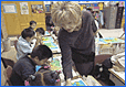
Making and Using a Floor Map of China: Video Segment
 Go to this segment in the video by matching the image (to the left) on your video screen. You’ll find this segment approximately 9 minutes into the video. Watch for about 6 minutes.
In this part of the video, students are making a floor map of China and labeling the important natural and human-made features.
- What prior learning is Ms. Norton asking students to use in making the floor map?
- How does Ms. Norton help students succeed at this task?
- How does she encourage students to help one another learn?
- What does she ask students to do with the finished floor map? Why is this an important part of the lesson?
- How would you describe the importance of hands-on learning?
- How does this activity appeal to different kinds of learners?
Connecting to Your Teaching
Notes
As you reflect on these questions, write down your responses or discuss them as a group.
Reflecting on Your Practice
- What are some skills that you integrate when teaching geography and culture? How do you decide which skills to include?
- What are the advantages and disadvantages of teaching an integrated curriculum?
- How do you make sure the requisite skill and content standards are addressed when integrating curriculum from other disciplines? Or is the integrated work considered “add on” to the primary subject matter?
- What topics and skills in your curriculum lend themselves to hands-on learning? What activities have you found successful at teaching abstract concepts?
- Give an example of a lesson in which you integrate other areas of the curriculum with social studies. How do you plan for such lessons?
Taking It Back to Your Classroom
- Choose hands-on activities related to the study of China, and link them to other areas of the curriculum. For example, ask students to make a replica of the Great Wall of China while learning about its history. Students could also study the Chinese New Year, make silk-screen prints, practice drawing Chinese characters, and create a display or presentation to teach other children or adults about China.
- Visit a museum with your students to study the art and relics of China. Have your students make a classroom exhibit displaying reproductions of cultural and historical Chinese artifacts.
- Use papier-mâché to make topographical maps of a region of the world. Encourage students and parents to work together on this geography/art project.
- As you study different countries, ask students to keep the products of their activities (such as maps) and put them in a scrapbook. Students will also enjoy comparing information about different countries (for example, form of government, major religions, official language, and statistics such as area, population, average education, average life span, and so on). Have students enter information from two or three countries into a spreadsheet and convert the data into a graph.
- After studying a particular region, ask students to create promotional materials about the place. Then have students write to the tourist bureau, government information agency, or chamber of commerce to get brochures, maps, and other information about the place they are studying. Ask students to examine the materials to determine what factors the host country, city, or town believes are important, and to compare these materials with the ones they created.
- Invite students to exchange letters or e-mails with students from a school in China or another distant region they are studying. Have students begin to explore the similarities and differences between themselves and their new pen pals.
Standards
 NCSS Standards
Expectations of Excellence: Curriculum Standards for Social Studiesdefines what students should know and be able to do in social studies at each educational level. This lesson correlates to the following standards for elementary school students:
I. Culture
Explore and describe similarities and differences in the ways groups, societies, and cultures address similar human needs and concerns; describe ways in which language, stories, folktales, music, and artistic creations serve as expressions of culture and influence behavior of people living in a particular culture; compare ways in which people from different cultures think about and deal with their physical environment and social conditions.
II. Time, Continuity, and Change
Demonstrate an understanding that people in different times and places view the world differently.
III. People, Places, and Environments
Interpret, use, and distinguish various representations of the Earth, such as maps, globes, and photographs; use appropriate resources, data sources, and geographic tools such as atlases, data bases, grid systems, charts, graphs, and maps to generate, manipulate, and interpret information; estimate distance and calculate scale; locate and distinguish among varying landforms and geographic features, such as mountains, plateaus, islands, and oceans.
IX. Global Connections
Explore ways that language, art, music, belief systems, and other cultural elements may facilitate global understanding or lead to misunderstanding.
Content Standards:
Geography, History
Resources
Print Resources![]()
For Students![]()
![]()
Chinese Academy of Science. The Population Atlas of China. English edition. New York: Oxford University Press, 1995. Currently out of print.
Clements, Jonathan. Chinese Life. Early Civilizations Series. New York: Barrons Juveniles, 2000.
Flack, Marjorie, and Kurt Wiese. The Story About Ping. New York: Viking Press, 1977.
![]()
![]()
For Teachers![]()
![]()
Davenport, Merle. Living Geography: China. Grand Rapids, Mich.: Instructional Fair, 1998.
Hopkins Tech. China! The Grand Tour. 1.0 ed. Hopkins, Minn.: Hopkins Technology, LLC, 1995. CD-ROM.
Smith, David J. Mapping the World by Heart. 6th ed. Watertown, Mass.: Tom Snyder Productions, 1999.
![]()
![]()
Web Sites
For Students![]()
![]()
![]()
A to Z Kids Stuff
Geared towards young children, this site includes a China section with an emphasis on significant facts and dates in Chinese history.
Scenery Pictures
This site features photos of China’s natural landscapes and diverse geography.
For Teachers
The East Asian Curriculum Project at Columbia University
The EACP provides educators of all grades with information, lesson plans, and curriculum ideas on Asia.
The United States Geological Survey
The USGS offers geography curricula based in games and map activities, for grades K-12.
The University of New Orleans
On this site, the Teaching Asia and Technology section features links, teacher resources, Asian Study Web sites, and other educational material on Asia.